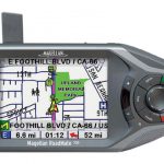
Magellan’s RoadMate 700 is a 3.25 inch by 6.5 inch by 2 inch, 13 ounce comparative to the TomTom Go. It has a 3.75 inch diagonal touch screen with full-color, high resolution, transflective TFT, backlight, and it automatically adjusts to light conditions.
It does not come with an internal battery, so there’s no taking it with you on walks, etc. You must keep it plugged up at all times via the car adapter, or the AC adapter, so it’s not terribly convenient. Most GPS devices these days have batteries, and can be taken from the car on walks, hikes, camping trips, etc. Not true with the RoadMate 700.
It is easy to use, and does come with preloaded and details maps of the United States and Canada. It also has over 2 million preprogrammed Points of Interest. You can search for fuel, restaurants, hotels, etc. Just touch the icon for a destination, and it gives you a phone number and an instant route to that spot.
You have choices in routes of shortest time, shortest distance, least use of freeways, or most use of freeways. There’s also an option to avoid toll roads. The results are displayed in either Map View, TrueView, or 3D split screen.
<
It can take 5-10 minutes to acquire the satellite signal. If you turn it on to acquire a signal in the same spot that it was turned off, then it will lock on more quickly. Magellen boasts that the acquisition time is only 60 seconds when cold, but this has been disputed by users.
It’s not a high tech GPS device, as we’ve seen from some of Magellen’s other series. What it is, is a navigational device, and nothing else. So, if you need navigation, and not Bluetooth, or music, or any of the normal “extras” that a lot of devices have now, then the RoadMate will certainly live up to your expectations. It does navigate well, and is accurate on its directions and voice prompts. If you’re looking for a little more than just navigation, I’d suggest checking into a more expensive unit. This one is great for navigation, beyond that, you’d be disappointed.
Learn More
Magellan RoadMate 700 North America
Imagine having a personal assistant in your car, guiding you turn by turn, with a friendly voice and visual signals, even when you don’t know the address. That’s what you get with the Magellan RoadMate 700 portable GPS vehicle navigation system. Forget about sorting through large folding paper maps or taking the time to print out Internet directions. With built-in maps of the 48 contiguous United States and Canada 1, simply turn it on and go! Select virtually any destination using the latest in full-color, touch screen technology or the dynamic backlit keypad and within seconds you’re on your way.
Your Magellan RoadMate 700 has over 2 million preprogrammed points of interest, making it easy to find your destination quickly and easily. Search by name or category for gas stations, restaurants, hotels, ATMs, sights, amusements and more, whether you’re driving cross-country or to an unfamiliar address across town. The Magellan RoadMate 700 is built on the same technologies as the Hertz NeverLost® system. Lightweight and truly portable, the Magellan RoadMate 700 goes wherever you go, from your personal vehicle to your business car, to your RV.1Includes the 48 contiguous United States and major metro areas and highways of Canada, not including Prince Edward Island and Newfoundland.
Hertz NeverLost® is a registered trademark of Hertz System, Inc.
Features
Easy-to-use – Quick access to features through simple touch-screen menus and keypad Turn-by-turn voice and visual guidance – BE THERE™ quickly and safely Built-in maps – 48 contiguous United States and Canada (Alaska or Hawaii not included) Auto Re-route – Never miss a turn and quickly get back on track whenever you take a detour QuickSpell™– Easily enter addresses with unique auto-complete feature Complete mobility – Transfer to any vehicle with no installation Over 2 million points of interest (POI) – Easily find gas stations, restaurants, ATMs, airports, parks and more Interactive POI icons – Touch an onscreen icon for a nearby destination; see phone number and get an instant route Customizable route method – Shortest time, shortest distance, least use or most use of freeways, avoid toll roads Route exclusion – Select street or freeways to avoid 3 easy views – Map View, TrueView™ 3D split screen, simple Maneuver List Address Book – Create and store personal points of interest for easy reoccurring trips Instant locate – One touch shows your location; quickly advise roadside assistance or emergency services
Specifications
Product Number: 980652-03
PHYSICAL
| Case | High-impact plastic |
| Base Map | Pre-loaded detailed maps of the U.S. and Canada |
| Size | 6.5″ W x 3.25″ H x 2″ D (W 16.51 cm x H 8.26 cm x D 5.1 cm) |
| Weight | 13 oz (368.5 g) |
| Display | 3.75″ diagonal touch screen: full-color, high resolution, transflective TFT, backlit, automatically adjusts to light conditions |
| Memory | 10 GB hard drive |
| Data Storage | Unlimited / Compact Flash (CF) Card compatible |
| Antenna | Built-in multidirectional patch |
| Keypad | Eight direct-access keys, plus power, volume and repeat buttons |
| Operating Range | 14 to 140°F (-10 to 60°C) |
PERFORMANCE
| Receiver | 14 channels, WAAS/EGNOS enabled |
| Acquisition Time | Hot: 20 seconds, Cold: 60 seconds, Initial: 5 minutes |
| Update Rate | Once per second |
| Accuracy | 3 to 5 meters (10 – 16 feet) – WAAS/EGNOS, < 7 meters (15 feet) – GPS only |
| Languages | Voice guidance in English, French, German, Spanish, Italian, Dutch |
POWER
| Source | 12 V AC or vehicle adapter |

